Alerts: The National Weather Service has issued a winter storm warning for the entire area from 10PM tonight through 10 AM Tuesday, for a threat of heavy snow and gusty winds.
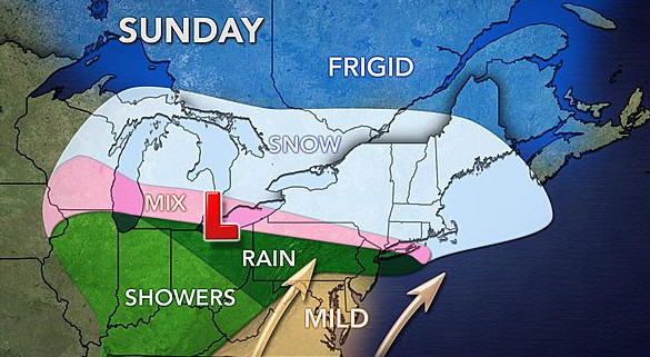
Overview: A stationary front is found over the region. To the north of the front, a strong ridge of high pressure is present. Along the front, a weak disturbance is currently moving through the region. This weak disturbance will provide periods of light to moderate snow through tomorrow evening. Behind this disturbance, a stronger disturbance (Alberta Clipper) will move in from the Midwest and along the Ohio River Valley. While this disturbance moves into the Mid Atlantic, it will transfer energy to a secondary area of low pressure that will form off the coast of the Mid Atlantic. This low will help throw some moisture into the region late on Sunday through Tuesday morning. Additionally with air flowing from high pressure to the north towards low pressure to the south of the area, expect enhanced areas of snowfall across eastern New England. Areas closer to the coast may see the higher snow totals from this event.
A ridge of high pressure will build in from the northwest on Tuesday. This will allow for dry conditions to return to the region late on Tuesday into the day Wednesday.
Projected Snowfall: 12-22 inches thru Tuesday morning
Forecast Timeline:
Tonight: Mostly cloudy with a periods of light to moderate snow. 80% chance of snow. Snowfall amounts between 1-3 inches. Low temperature around 17F. Winds from the south-southwest at 5-10 mph.
Sunday, January 8th: Mostly cloudy with a chance of light snow showers. 60 % chance of snow. Snowfall amounts between 1-3”. High temperature around 20F in the morning, then dropping into the 10’s afterward. Winds from the east at 10-15 mph.
Sunday Night: Mostly cloudy with periods of light to moderate snow through the evening. Then periods of moderate to heavy snow moving in toward daybreak. Snowfall amounts between 4-7”. Low temperature around 15F. Winds from the northeast at 15-25 mph, with wind gusts above 30 mph likely.
Monday, January 9th: Mostly cloudy with a chance of snow. High temperature around 19F. Snowfall amounts between 4-7”. Winds from the northeast at 15-25 mph, with wind gusts above 30 mph likely.
Monday Night: Mostly cloudy with periods of light to moderate snow. Snowfall amounts between 1-2”. Low temperature around 15F. Winds from the east-northeast at 15-25 mph, with wind gusts above 30 mph likely.
Tuesday, January 10th: Mostly cloudy in the morning with a slight chance of snow showers. Little breaks of sun possible in the afternoon. Snowfall less than 1”. High temperature around 22F. Winds from the northeast at 10-15 mph, with higher gusts likely.
Tuesday Night: Mostly clear. Cold. Low temperature around 2F. Winds from the north-northwest at 5-10 mph.
Wednesday, February 11th: Mostly sunny. High temperature around 15F. Light winds from the north-northwest.
Impacts: Light to moderate snow is forecasted to continue for tonight through tomorrow evening. Travel won’t be impossible, but will be very slow tomorrow. Make sure to give yourself time to anywhere you have to go.
Heavier snow will move in early Monday morning into Monday evening. Additionally, wind gusts are forecasted to pick up during this time. This will result in low visibilities for traveling. With the timing expected to greatly impact the morning and evening commute, I expect some businesses and school cancellations for Monday.
During Monday night, periods of light to moderate snow and blowing snow will occur into Tuesday morning. With the snow expected to move out of the area by Tuesday morning, there might be some delays for the morning commute on Tuesday.
Note: A lot of uncertainty relies on the duration and intensity of the snow bands during this event. With heavier snow expected for areas closer to the ocean, it is not set how long and if these snow bands will make there way towards the Worcester area. If these snow bands linger over the area, higher totals around the upper range of my snow total forecast is possible. If these snow bands don’t last long or don’t make it to the area, snowfall totals around the lower range of my snow total forecast are possible.
If anyone has any weather related questions, feel free to email me at postle@gmail.com


