by Meteorologist Jeb Postle
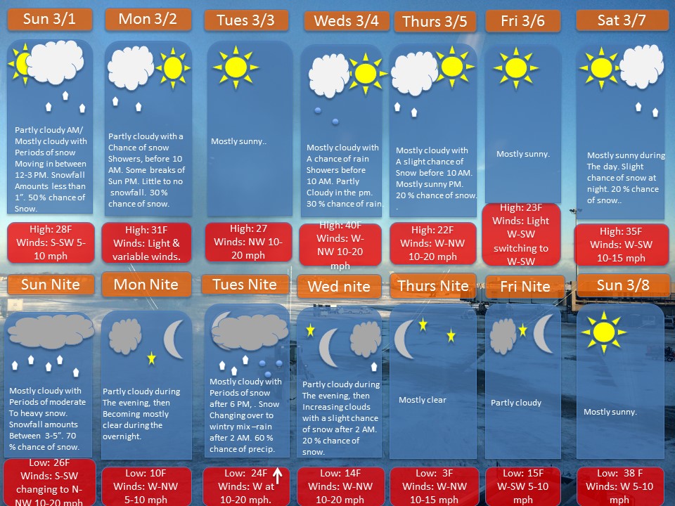
Total Snowfall: 3-6” of wet snow
Alerts: The National Weather Service has issued a Winter Weather Advisory in effect from noon today till 7 AM tomorrow morning for a threat of heavy wet snow.
Overview: A storm system will move into region from the west, providing periods of snow beginning in the afternoon through Monday morning. The storm system will quickly move out of the region Monday morning, as a ridge of high pressure will build in from the west. Expect temporarily dry weather through Tuesday afternoon. A more vigorous storm system will move in from the Great Lakes late on Tuesday. This time, there will be surge of warmer air that will gradually push into the region during this event. This will result in a snow to freezing rain and eventually rain on Wednesday.
A cold front will move through the region Wednesday afternoon into Wednesday night. There may be a slight chance of snow late Wednesday night into early Thursday morning.
A ridge of high pressure will build in from the west on Thursday, providing dry and temperatures near average for this time of year into the weekend.
Impacts: If anyone has to do any errands, the best time to do so is this morning. The snow will start falling this afternoon into the night. Roadways will become slippery. Much of the snow should wind down during the early morning hours, with perhaps a light snow shower possible into the morning commute. Some roadways may be slippery in the morning, which may lead to some school delays. The good news is that temperatures should climb to around 30 degrees, with breaks of sun from mid morning into the afternoon. This will allow for snow to melt on roadways.
Note: If anyone has any weather related questions, feel free to email me at jebril.postle@gmail.com